Precise harvest forecasts from space
Advertisement
The ETH spin-off Terensis uses satellites to predict crop yields and climate risks such as drought or frost. This not only helps farmers with their planning. Authorities and insurance companies can also better assess damage and treat it more cost-effectively.

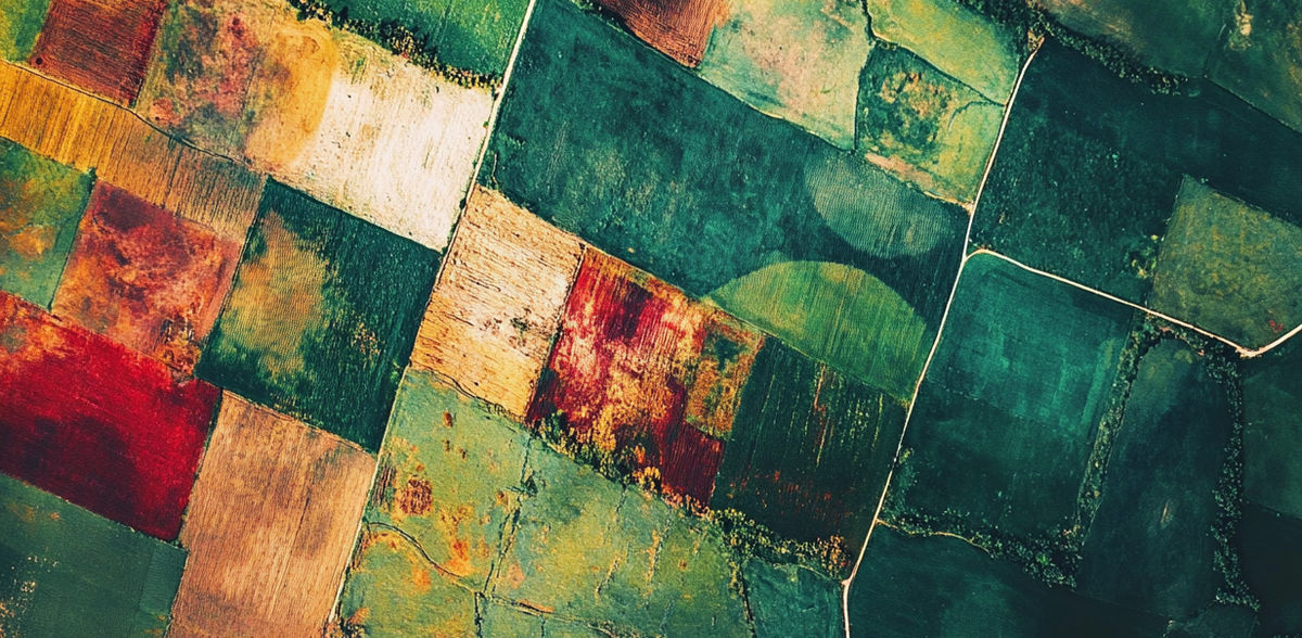
Entire cultivation areas or individual fields can be digitally monitored on the Terensis platform.
Screenshot: Terensis GmbH
"There's no question that farmers know their fields much better than we do," says Gregor Perich. "They know which are better and which are worse and what they can achieve where and how. However, we can help them to reduce uncertainties, save time and intervene in good time in the event of risks."
The agricultural scientist from ETH Zurich shows a map of Switzerland on his laptop screen: between Lake Geneva and Lake Constance, you can see lots of little patches in shades of red, green and yellow. "These are the individual cultivated fields, orchards and vineyards in Switzerland. We can predict the yield for each of them up to two months before the harvest. The greener the color, the higher the yield."
Perich zooms into the interactive map and thus into the individual plots - each consisting of different colors. "Our dashboard allows you to check the current status of any section of the field. The farmer can see at a glance whether the crops are on track or not - and receives tailored recommendations for action."
Satellites see more
The detailed location-based database that Perich shows is a "digital twin", i.e. a virtual image of reality. The digital twin combines biophysical models with real-time satellite data to simulate the development of crops from sowing to harvest. In addition to the expected crop yield, it also provides information on the current biomass - from which the yield is calculated - the expected flowering date and the ideal harvest time.
The use of satellite data in Swiss agriculture is still cautious. Yet the potential is huge. "With satellite images, we can observe things that we can't see with the human eye," says Lukas Graf. Like Perich, the geoinformatics specialist did his doctorate in the crop science group led by ETH Professor Achim Walter.
"Among other things, satellites measure how much radiation from the sun shining on a field is reflected. Depending on the condition of the plants, they return more or less of the radiation." For example, if the leaves of a plant are a certain size and are at a certain angle, they send a certain amount of radiation back to the satellite. "This allows us to draw very precise conclusions about the plants," says Graf. "The satellite images can tell us, for example, whether the plant is under drought stress or whether it is threatened by fungal infestation."
Warning of weather risks
This satellite information is linked to a weather forecast tailored to the location. "In combination with our agronomic knowledge, we can provide a targeted risk assessment and recommendations for action, for example in the event of frost, drought or impending fungal infestation with Fusarium," adds Perich.
"The farmer always knows more about the field than we ever can. We are careful not to explain the world to him or her. But we do help to save time - and also fertilizer." Gregor Perich, co-founder of Terensis
With the help of the digital twin, the farmer can now see at a glance whether a part of the crop is under threat and can, for example, apply fungicides specifically where they are needed, close the hail nets in good time or light frost candles. "Our model is updated twice a week. So we always know what stage the crops are at," says Perich. The stage is decisive for whether and how action needs to be taken. Take vines, for example: If the bud has not yet sprouted, the woody part of the vines can tolerate much more. As soon as the bud is there, it becomes critical. Frost is then particularly bad.
The current year shows how unpredictable nature is. First it was very warm, then frost came in April at an unfavorable time for the plants. And then it rained very often, with temperatures that were too high. "Fungal infestation is a major problem for agriculture in 2024. If grain is infested with Fusarium, it loses value, and in extreme cases it can no longer even be used as animal feed," says Graf. This makes real-time monitoring all the more important in order to be able to intervene in time.
However, the digital twin doesn't just support farmers in the short term. "In various conversations, farmers have told us that a digital map with all the plots they farm can also help them plan their strategy in the long term," says Graf.
From research to the market
As doctoral students, Perich and Graf were already looking for solutions as to how agriculture in small-scale Switzerland could benefit from the latest satellites from the European Space Agency (ESA). With the support of a Pioneer Fellowship, they now want to bring their research to the market. At the beginning of May, the two founded the company Terensis, named after a Roman goddess responsible for threshing grain. Terensis has just been awarded the ETH spin-off label.
Terensis' technology is intended to serve as a decision-making aid for the entire agricultural sector. Farmers receive support in planning their daily work and in consultations with the cantonal agricultural offices, for example when it comes to obtaining approval for the use of pesticides. "You can look at a map together and see the same thing without the farmers having to explain at length which fields or problems they are talking about," says Graf. "This allows the discussion to be data-based and efficient for each location on the field. And the facts are tangible and, above all, verifiable," emphasizes Graf. This means that a fact-based decision can be made quickly and jointly. This saves time on both sides.
Digital information is also interesting for agricultural insurers, Graf emphasizes: "Insurers often don't want to know in detail what is going on where. However, they are interested in the fluctuations in yield over the years and across larger areas. They use this to calculate the insurance premiums." Most assessment processes at authorities and agricultural insurance companies are still carried out manually. "If they can make decisions a minute faster each time with our technology, a lot of time can be saved overall."
"Whether farmer, insurer or politician: thanks to our technology, everyone has the same database and the circumstances are verifiable. "Lukas Graf, co-founder of Terensis
Politicians also prefer to rely on a data-based decision-making basis, the two researchers add - for example, when it comes to releasing research funds for the breeding of varieties adapted to the location or for special permits for pesticides. "With data-based tools like ours, you can reduce bureaucracy."
As simple as Google Earth
The platform should be as easy to use as Google Earth, says Perich. "You don't have to be an expert in map reading to use Google Earth. Our platform should also be as intuitive as possible."
There are several companies working on digital solutions for agriculture, says Perich. "What sets us apart from the others: We bring the two crucial production factors in agriculture, soil and weather, together on one platform." Graf adds: "Nobody wants to have ten different subscriptions to check the weather, check the biomass or get a fertilizer recommendation. We bring it all together on one platform."
In their research, they have now proven that the technology works, says Perich. Now it's time to implement it - and a rethink is needed. "Changing previous habits and methods is probably the most difficult task."
Terensis is supported by the ESA Business Incubation Center Switzerland (ESA BIC CH). ESA BIC CH is a program of the European Space Agency (ESA), which is supported in Switzerland by ETH Zurich. It supports young entrepreneurs working on space-related technologies.
Note: This article has been translated using a computer system without human intervention. LUMITOS offers these automatic translations to present a wider range of current news. Since this article has been translated with automatic translation, it is possible that it contains errors in vocabulary, syntax or grammar. The original article in German can be found here.
Other news from the department business & finance


Most read news


More news from our other portals


Something is happening in the food & beverage industry ...
This is what true pioneering spirit looks like: Plenty of innovative start-ups are bringing fresh ideas, lifeblood and entrepreneurial spirit to change tomorrow's world for the better. Immerse yourself in the world of these young companies and take the opportunity to get in touch with the founders.